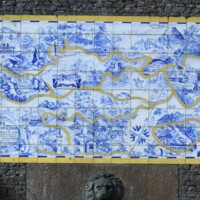
A map of the Floresta da Tijuca
Dublin Core
Title
A map of the Floresta da Tijuca
Description
Map of the Tijuca forest made in in azulejos (Portuguese ceramic tiles) and designed by Castro Maya in 1943-46. The Tijuca forest was the first protected public area established in Brazil by Dom Pedro II in 1861, and efforts to reforest the land began under his reign. At least six enslaved workers were in charge of replanting trees in this forest that had been cleared for growing coffee and raising livestock in the 1700s.
Creator
Daniel Domingues
Publisher
Lynne Lee
Date
June 2022
Still Image Item Type Metadata
Original Format
photo
Citation
Daniel Domingues, “A map of the Floresta da Tijuca,” Diasporic Cultures of Slavery: Engaging Disciplines, Engaging Communities, accessed September 19, 2024, https://digitalprojects.rice.edu/MellonSawyer/items/show/154.
