Jingban tianwen quantu:
Capital Edition Of A Complete Map (Of The World Based On) Astronomy

Dublin Core
Title
Jingban tianwen quantu:
Capital Edition Of A Complete Map (Of The World Based On) Astronomy
Capital Edition Of A Complete Map (Of The World Based On) Astronomy
Description
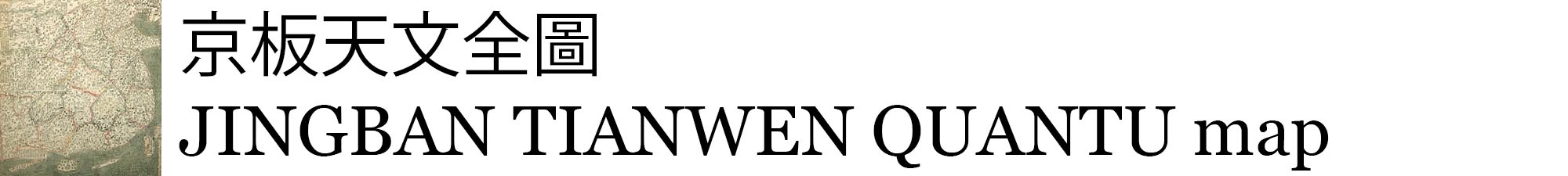
The Jingban tianwen quantu reflects a Sinocentric world view in which every country but China is relegated to the periphery. At the top is a panel with two side-by-side hemispheric world maps. Korea and the islands of the east Indies are illustrated to the east and south of the China land mass, while a shrunken Europe is squeezed into the upper left corner.
It is a woodblock map on rice paper, and it features outline color with a green sea. In two places the image is interrupted by a thin band of white space, dividing the map into thirds.
It is a woodblock map on rice paper, and it features outline color with a green sea. In two places the image is interrupted by a thin band of white space, dividing the map into thirds.
Creator
Ma Junliang
Source
Rice University Archives, Map Drawer 7, Woodson Research Center, Fondren Library, Rice University
Maps (G7821 .A5 1761 M3)
Maps (G7821 .A5 1761 M3)
Publisher
Rice University
Date
ca 1761
Rights
This material is in the public domain and may be freely used. This work is licensed under a Creative Commons Attribution 3.0 Unported License.
Format
maps
Type
Still Image
Identifier
wrc06057
Citation
Ma Junliang, “Jingban tianwen quantu:
Capital Edition Of A Complete Map (Of The World Based On) Astronomy,” JINGBAN TIANWEN QUANTU map, accessed May 16, 2024, https://digitalprojects.rice.edu/wrc/jingban-tianwen-quantu/items/show/1.
Capital Edition Of A Complete Map (Of The World Based On) Astronomy,” JINGBAN TIANWEN QUANTU map, accessed May 16, 2024, https://digitalprojects.rice.edu/wrc/jingban-tianwen-quantu/items/show/1.